While everyone else drove out of the water, they drove into it.
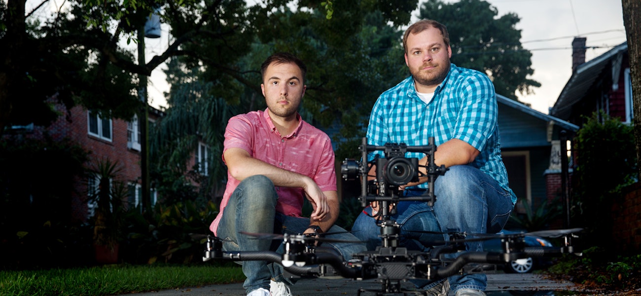
Paul Charbonnet and Josh Rogers barreled their trucks into deep, dangerous waters over and over during the floods. Then, they launched their drones into the sky to film the worst-affected areas.
Co-owners of Atmosphere Aerial, the duo normally uses their drone cameras to shoot aerial footage for films or media outlets such as National Geographic, The New York Times and the Travel Channel.
But the morning of Sunday, Aug. 14, Charbonnet woke up at 6 a.m. to a desperate voicemail from a woman in Flint, Michigan. She couldn’t reach her elderly mother in Baker and was looking for someone to take a picture of her house. “Please,” she begged. “I don’t know if my mother is alive or dead.”
Charbonnet was dealing with his own flooding problems. His parents’ two homes had flooded, and he and his wife had been forced to evacuate their own house.
But after hearing the woman’s message, he dropped everything and got in his truck. He drove toward her mother’s street, launched his drone and sent her the pictures.
“Thank you. Thank you. Thank you,” she wrote back. “Her house is safe. She’s alive.”
Rogers and Charbonnet had already posted a few flood videos on Facebook. But the Flint woman’s response shot their efforts into overdrive.
“Seeing how it affected her … it touched my heart,” Charbonnet says today, his voice breaking. “We were the only ones who could give people that view, and I thought because I can, I should.”
So they followed the water as it saturated the Capital Region. Their drones soared 200-300 feet above Denham Springs, Central, North Baton Rouge, Zachary, Baton Rouge proper, parts of Ascension Parish and beyond.
They visited as many neighborhoods as they could, entering areas where the only other remaining humans were on boats. Twenty-minute drives turned into hours because they had to turn around so often.
For safety reasons, they never sent their drones more than a mile away. But this meant they had to get as deep and as close as they safely could to the worst areas.
“If we weren’t crossing water, we weren’t in the right place,” Charbonnet, 33, says.
He recalls a close call on Highway 22 in Sorrento, where the water was much higher and faster than he’d anticipated. He managed to drive to a drier spot to get the video, and the risk paid off.
“Thank you for all that you have done,” one of that video’s 40,000 viewers wrote. “You have given so many people a sense of closure.”
They stayed up late each night responding to Facebook messages. They’d get up to 250 requests per day to visit different neighborhoods.
Within one week, they made nearly 60 flood videos, each offering thousands of people a view of their homes they couldn’t have otherwise seen. One video showing the scene at Old Hammond Highway at Sherwood Forest Boulevard got more than 726,000 views and 13,000 shares. Another of 1-12 between Millerville Road and O’Neal Lane had more than 312,000 views.
Now that the flooding is over, Atmosphere Aerial has offered free footage to those who need it for insurance purposes. They also hope their videos will change the opinions of those who want to ban drones for privacy reasons. Drones aren’t here to spy on the community, Rogers, 22, says. And if drone usage had been illegal, it would have been impossible for them to offer the comfort and closure they gave to so many people.
Today, strangers see Rogers and Charbonnet in their Atmosphere Aerial T-shirts and stop them to thank them. But they always say thank you back.
“If it wasn’t for the people on Facebook telling us when and where to go, this never would’ve happened,” Charbonnet says. “Thousands of people shared addresses. Just one address showed a thousand other people their houses.” facebook.com/atmosphereaerial
This story was originally published in the October issue of 225 Magazine.